
Turning Data Into Information Using ArcGIS
Module 6: Uncertainty (in numeric values and spatial data)
Problem
The problem is to reference a digitized street addition to an existing street map by transforming digitizer measurements into real-world coordinates given GPS control points. Uncertainty in the results will be measured.
Analysis Procedures
The Editor and Spatial Adjustment toolbars were used within ArcMap to perform the transformation of position coordinates so that the street addition was in the same coordinate system as the existing street map. A street map, a digitized street addtion, and GPS control points consisting of known street locations for this addition were provided. These control coordinates/points were selected as the adjustment data, such that all features in the street addition layer could be transformed using the Set Adjust Data command from the Spatial Adjustment toolbar. The Affine transformation method was used for adjustment. Selecting the Links command from this toolbar opens up the GPS control points file, so that it could be added to the map. Next, double-clicking on each control point followed by snapping to its corresponding digitized street endpoint, created displacement links between the source and destination points. This table shows the Root Mean Squared Error used to describe how consistent the transformation is between different links. Because the calculated transformation values were acceptable, they were applied to all feature coordinates in the street addition file and a projection defined that matched that of the existing street map. This ensured the addition could properly rest within the subdivision.
Results
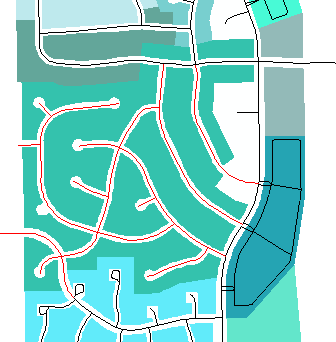
The screen capture above shows the street addition (Red) successfully georeferenced to the existing subdivision (Black).
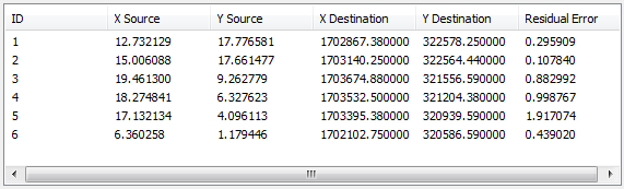
The screen capture above is from the View Link Table of the Spatial Adjustment toolbar. The total error, or Root Mean Squared Error, is computed by taking the root mean square sum of all the residuals.
This value describes how consistent the transformation is between the different control points (links).
Application and Reflection
The transformation process in Module 6 converts and scales digitized locations (e.g., in measurements of inches) into real-world coordinate locations using map units (e.g., feet) through displacement links. A projection can then be defined if needed, as the default coordinate system of the digitized data layer is assumed in the geographic coordinate system and uses decimal degrees for its units. Aerial photography images are often referenced within CAD drawings as a basemap. Images without a world file, but corrected for distortions, could be orthorectified using GPS surveyed control points and projected. A world file could be created upon exporting the image from ArcMap, with both files now correctly referenced in the coordinate system of the CAD drawing.