
Turning Data Into Information Using ArcGIS
Module 5: Optimization and Hypothesis Testing
Problem
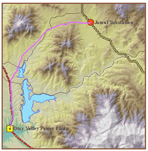
The problem is find the least cost path for a power line between a power plant and a substation.
Analysis Procedures
Two point files representing source and destination sites for the power plant and substation, respectively were brought into ArcMap for solving the problem in Module 5. A digital elevation model (DEM) was provided, and the Spatial Analyst, Slope tool was used to create a percent slope map. Slope values were then reclassified on a scale of 1-10 with higher values representing steeper slope ranges. Using the same tool, a land use layer was also reclassified to the same scale. Land use types that were cost-prohibitive were assigned higher values. Values from the two surfaces were combined using Math tools to create a total cost surface. Lakes and airstrips to be avoided were assigned NoData values. This surface was then used to compute a cost-weighted distance analysis using the Spatial Analyst, Cost Distance tool. The input feature source data included the power plant, and both distance and backlink (direction) raster names were specified for output. Finally, the least cost path was computed with the two rasters as input for the Spatial Analyst, Cost Path tool and the feature destination input being the substation. The result was a path from the power station to the substation that avoided steep slopes and costly land uses.
Results
The screen capture below illustrates the least cost path (light violet) from a power plant to a substation.
Application and Reflection
Solving the problem in Module 5, suggested other factors for inclusion in the “cost” surface. In building a highway for instance, residential area noise pollution and endangered/threatened wildlife habitat disturbance are minimized in the corridor planning process. These “costs” could be factored with higher values and weighted, if necessary, to provide individual cost surfaces.