
Turning Data Into Information Using ArcGIS
Module 4: Transformations and Descriptive Summaries
Problem
The problems involve 1) finding land use, census tract layers and schools within one-half mile from a stream and spatially joining their attributes so that queries can be performed, 2) interpreting surfaces from elevation measurements via two different methods and comparing the results, 3) determining patterns from crime occurrences, 4) helping a furniture store owner determine the best place to relocate his store based upon data he has collected on customer spending and distances traveled, and 5) determining population and birth/death distributions for regions of Italy given table data, as well as how best to display this information graphically. The objective in the last exercise is simply to explore spatial dependence and fragmentation of vegetation types within a watershed.
Analysis Procedures
To find land use and other points of interest within ½ mile of a stream, a buffer was first established around the streams. The land use and census tracts were then be clipped as part of a polygon overlay to separate layers to include only those areas and points within the buffer. To determine the distance between schools (a point layer) and the clipped census tracts (a polygon layer), a spatial join was employed to show the schools closest to each census polygon and the calculated distances included within the target layer. The Union tool was then be used to combine this resulting layer with the clipped land use layer to contain attributes of all to determine land uses that have growth rates (according to census data).
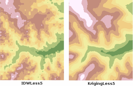
To solve the interpretation problem, the Spatial Analyst tools using Inverse Distance Weighting (IDW) and Kriging interpolation methods were employed upon a set of elevation points. The same data with 5% of sample elevation points removed were interpolated to produce comparable surfaces. The missing 5% (control) points were displayed within ArcMap on top of the two latter surface layers. Using the Identify tool and clicking on control points within ArcMap, displayed the differences in elevation values between the interpolated surfaces and the control points and thus, helped cross-validate the results.
To analyze concentration patterns, crime occurrence data was used as input to the Spatial Analyst, Kernel Density tool. Search radii were specified to create three density surfaces of occurrences for murders, thefts and assaults. Density surfaces were again created for burglaries selected by attributes of either “AM” or “PM”. Distinguishing these two surfaces allowed for police departments to alter patrol strategies during the two time periods.
To solve the problem of finding the optimal location for a new furniture store, customer spending and distances were examined using statistics tools from the Selection menu. The distance each customer travels to and from the store was also examined by spatially joining customer and store layers. The resulting new layer had the distance for each customer calculated in the attribute table. Additionally, opening the attribute table of this layer, right-clicking and choosing Summarize for the ZIP field, and then selecting the TOTAL statistics option created a statistical summary table to find which zip codes had the most customers and generated the highest revenue.
The simplest way to determine population and birth/death distributions by geographic regions is by accessing histograms through the Statistics dialog box for table fields, such as population. To have more control in the way these histograms were displayed, the information was accessed through the Layer Properties dialog box. The charts option of this same dialog box was used to symbolize total annual births and deaths for each region using pie and bar charts.
To explore the concept of spatial dependence, old vegetation polygon layer was compared with a new one. Fragmentation of a new vegetation layer was determined by comparing polygon count and size between this and an older vegetion layer via the Statistics dialog box of the layer’s attribute table. It can also be determined from the map display. Compactness may also be an indicator of the degree of fragmentation, and was accomplished by populating the attribute table using an expression (.cal file) applied to all polygons of both vegetation layers. A value of 1 indicates perfect compactness (a circle). The larger the value, the less compact the shape. The mean value from both layers were compared by opening the attribute tables and displaying field statistics, as before.
Results
Below are screen captures of the results from solving Problem 2. Notice the difference in both methods used, and the influence on results when control points are removed for cross-validation.
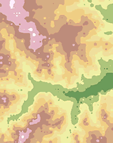
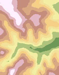
Interpolation using IDW and Kriging methods
Application and Reflection
In Module 4, it was shown that interpolation of elevation surfaces is affected by sample size and sample selection. The choice of interpolation method also determines how accurate an elevation surface is in depicting terrain (i. e., streams, cliffs, mountains, etc.). An accurate surface is necessary for floodplain and erosion modeling, for instance. They are also used to orthorectify aerial images. The creation of density raster surfaces from discrete crime occurrences, presents patterns of concentration not otherwise seen from viewing the point data alone. An appropriate search radius is necessary. Too large a radius tends to generalize the data, while too small a radius would create “islands” of concentrations, not differing much from the original point data. Using pie and bar charts showed how data could be related (annual births to deaths by region). Histograms are a great tool for illustrating population distributions or temperature and precipitation distributions over an area at a particular time, or the frequency of sales for different product offerings.