

Engineering & Science Based Services
Integra Engineering & Science Services, PLLC ("Integra ESS") provides both sound science and engineering solutions to its clients in stormwater permitting matters. With over 10 years of experience working for regulatory agencies, the owner brings to the company the same high-quality assurance standards the agencies have come to expect. Click on the following links, or scroll down the page to peruse the entire list of services this company provides.
Post-Construction, Stormwater Control Measure Inspections (BMP Inspections)
GIS Mapping & Modeling
Training & Continuing Education
Contract Services
Post-Construction, Stormwater Control Measure Inspections
Integra ESS offers inspections and maintenance recommendations for commercial realtors and homeowner associations as may be required by their municipalities. These may include retention or wet ponds, detention or dry ponds, constructed wetlands, bioretention basins or rain gardens, level spreaders, swales, regenerative stormwater conveyances (RSCs), or permeable pavement. The owner is NC Certified in BMP/SCM Inspection & Maintenance (#1934) and has conducted inspections and coordinated with local landscapers for maintenance on behalf of realty companies, and in accordance with municipalities, such as the City of Raleigh. Find out more about the owner's experience with post-construction SCM inspections through the About Integra section of this site. If you are a private land owner or landscaping company needing consultation for SCMs (BMPs), then Integra would be glad to assist you.
 Integra Engineering & Science Services, PLLC has recently been accepted into the City of Raleigh's Stormwater Inspections and Maintenance Program (SIM) as a professional meeting the requirements and understanding of standards held by the City for upkeep of stormwater control measures located within its ETJ.
GIS Mapping & Modeling
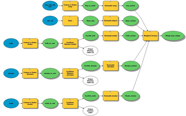
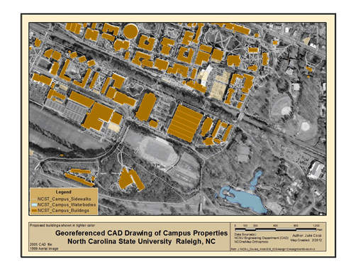
Geographical Information Science (GIS) has often become an integral part of engineering planning and designs. Integra ESS offers mapping, modeling and other analytical services to clients in their planning efforts, and even their every day needs. Examples of services this firm provide include, but are not limited to:
- Least cost path derivations for determining the best routes for pipelines, truck routes, etc.,
- Site suitability analyses for determining the most appropriate sites for SCMs, well pad locations, parcel or other types of development,
- Creating and/or maintaining property or resource inventories, and mapping them through the use of a spatial database, such as that used for NPDES MS4 programs,
- Nutrient modeling for determining nitrogen or phosphorous loadings in relation to TMDLs.
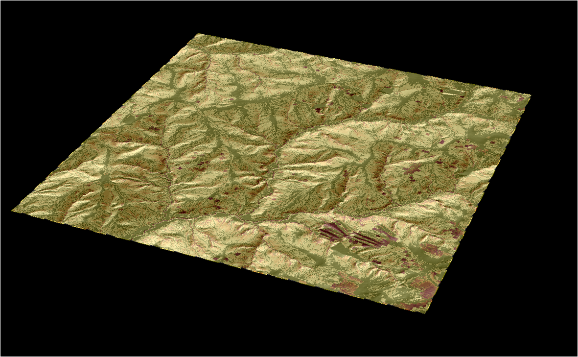
3D Model
Through Integra's GIS Services, planners and realtors can be assured that the most efficient routes for moving products and the most desirable sites for locating operations will be selected based in accordance with their criteria, and that of imposed government regulations. Likewise, stormwater managers can possess a well-managed inventory of their Stormwater Control Measures (SCMs), storm drain system outfalls, and all system components in order to better maintain their inventory. Agronomists or farmers can be better equipped to anticipate soils losses in terms of quantity, location and time through more reliable analyses than through non-GIS estimating methods.
Integra ESS can also provide for simple task orders, such as converting GIS files for use in CAD applications, querying data not readily accessible by the client, or performing statistical analyses. For instance, if you are a Forester or Logger, you would likely be interested in mapping riparian buffers and Streamside Management Zones (SMZs), and in deciding skid trail and stream crossing locations as part of your pre-harvest plan.
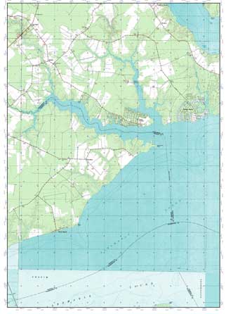 Integra ESS can provide planning tools such as topographic maps, soil survey maps, and aerial or satellite photos to assist in laying out entrances, trails, crossings, and SCMs (BMPs).
 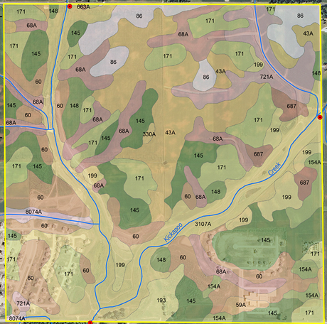 Through GIS, we can also maintain your timber and SCM/BMP inventories. If you work in the oil & gas industry, you may need an analysis for determining how many and how close underground water sources are to your drilling pad, and what the baseline water quality data is at that location.
USGS Topographic Map (Left) and NRCS Soils Map (Right)
 The owner has worked with GIS since 2004, integrating the science into special projects, such as those mentioned above, and into engineering work flows. Integra uses ESRI's ArcGIS products, and can work with multiple data types including CAD, DEMs, TINs, imagery, and LiDAR. These formats can come from national, local, or even client harvested datasets to produce maps, presentations, or tabular results specifically suited for your needs. Collaboration has never been easier with ArcGIS Online, allowing Integra to develop and easily share maps and data with clients.
View the full web mapping application
An Inspections Routing Map created for a client, providing optimized routes for multiple inspectors
Through ArcGIS Online, inspectors with a listing of project sites, along with known origins and a destination were imported and geocoded using available basemaps. A routing analysis was performed which assigned stops to each inspector in a manner that provided the most efficient route, collectively, from their starting points back to a central office. A single origin or multiple destinations (such as if inspectors returned to their homes) can also be analyzed. Click on the routes and stops in the map for attribute information. A second analysis provided a coverage area (polygon feature) within a specified driving radius (or time) which could prove useful for the case where a supervisor wanted to limit driving distances in the event of an employee vehicle breakdown, or should the company like to show a coverage map to potential clients as part of a marketing campaign.
Visit the owner's personal GIS Porfolio for examples of past assignments and qualifying geospatial skills.
Training & Continuing Education
Continuing education for engineers and surveyors needing Professional Development Hours (PDHs) is available. The owner is an author of two continuing education courses: Introduction to GIS and GPS for Engineers and Surveyors (4 PDHs) and GIS - Beyond the Basics : Web Maps and File Sharing Services (7 PDHs). Both of these courses provide valuable skills for those incorporating Geographical Information Science into their workflows, and/or desiring to work through Cloud-based services. Courses in Hydrology & Hydraulics, Stormwater Control Measure Designs, Low Impact Development, and Engineering Ethics are also available. Integra Engineering & Science Services, PLLC contracts with a continuing education provider for engineers and surveyors across the United States. Over 100 online courses are offered that can be taken 24/7 at your convenience. The vast majority of these courses are accepted by engineering boards in all states. In particular, the former GIS-based course is a 5-star rated course that made the Top 20 list in its first year, moved up to the Top 10 list, and is currently rated #6 in sales for the company. The latter course is a new release. If you are looking for access to convenient and affordable training for your license, contact Integra ESS!
Contracts
Most, especially long-term or larger scoped projects, are performed under contract. Contractural arrangements can clearly define the scope of work required thus minimizing, if not avoiding, misinterpretations and losses for both parties involved. Integra ESS uses Engineers Joint Contract Documents Committee contracts (otherwise known as EJCDC documents) as endorsed by the National Society of Professional Engineers. These documents are written with the intent to protect the interests of both parties. Visit the NSPE site for more information on the benefits of these documents or contact us if you have any questions.